 Catálogo de datos del IEO
Keyword
Cotes De La Manche
9 record(s)
Type of resources
Categories
Topics
INSPIRE themes
Keywords
Contact for the resource
Provided by
Years
Formats
Status
-
<p>Sea recovery of all components of a stratospheric balloon: balloon envelope, parachutes, and gondolas. Test of new gamma detectors and characterization of solar panels for the Strateole project. There has been no work done at sea after balloon fly. The balloon flight took place. The climb path was consistent with the expected. However the ceiling track was a little south and a little slower than expected. The ball has arrived above the sea but too south. Down a bit low, he found the westerly winds that brought him back to earth. Separating late flight and recovery have made campaigning in the Basque country.</p>
-
Characterization of the Quaternary and Neogene sedimentary cover of the NW Atlantic shelf zone off Morocco and Quaternary deformations. This falls under the ANR ISIS project.
-
Optical (Rrs) and hydrological measurements to determine and quantify particles in suspension and dissolved organic matter at the surface of the water using satellite images. The measurements taken along the Basque country coast are used to validate the algorithms developed using data from the BATEL-1 mission. An additional objective is to supply in-situ optical and hydrological data for the doctoral theses of C. Petus and S.Novoa. The oceanographic mission took place in 2 parts due to a mechanical incident aboard RV Côte de la Manche. The cruise falls under the inter-régional Aquitaine-Euskadi (OOSSEA) programme, CIFRE contract.
-
Optical (Rrs) and hydrological measurements to determine and quantify particles in suspension and dissolved organic matter at the surface of the water using satellite images. The measurements taken along the Basque country coast are used to validate the algorithms developed using data from the BATEL-1 mission. An additional objective is to supply in-situ optical and hydrological data for the doctoral theses of C. Petus and S.Novoa. The oceanographic mission took place in 2 parts due to a mechanical incident aboard RV Côte de la Manche. The cruise is part of the inter-regional Aquitaine-Euskadi (OOSSEA) programme, CIFRE contract.
-
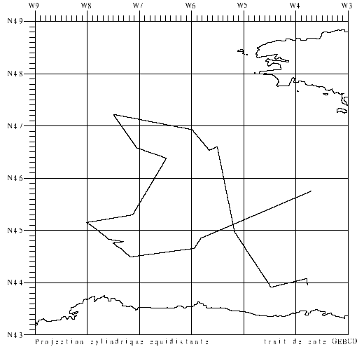
-Validation of surface salinity measurements using drifting buoys. Three models of drifting buoys (17 buoys in all) were deployed in the Bay of Biscay on 2 April (R/V Thalassa trip) and on 2-3 May (COSMOS1 aboard Côtes de la Manche). This involved passing close to the buoys, taking samples, TSG measurements and CTD hauls to validate the data. Two sections taken by CTD probe in front structure eddy (for the CONGAS programme). Retrieval of a prototype PROVOR-CTS3 float deployed in May by the Côte d'Aquitaine vessel. 9 CTD sensors to be attached to elephant seals were tested (mounted on SBE25 CTD during profiles). This falls under the COSMOS project, headed by J. Boutin and G. Reverdin.
-
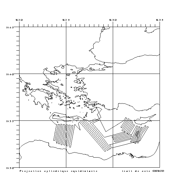
<p>The MARLBORO cruise project aimed to study Post-Messinian tectonic evolution in the South Alboran basin (Morocco). The presence of sediment formations, especially contourites (sediments deposited or reworked by marine bottom currents) and instabilities, deposited since the end of the Messinian (approx. 5.33 Ma), provide us with top rate sedimentary markers to recreate the tectonic evolution well. Moreover, the region is affected by strong quakes and by slope instabilities which cause concern. Although active accidents have been identified and recently mapped on the Andalusia margin, no such detailed studies have been conducted yet on the Moroccan margin. The Xauen/Tofino and Alboran ridges off Morocco, in the south of the Alboran Sea, were chosen for the study zone since they show both past and current signs of strong tectonic deformation, underwater landslides and activity of bottom currents whose contourite type deposits can provide an excellent stratigraphic marker. The cruise's objective was the imaging of post-Messinian structures using medium resolution reflection seismics. The cruise (7 days in the zone) made it possible to acquire about 1,100 km of reflection seismic surveys along the 15 profiles perpendicular to the ridges, and 3 profiles parallel to the ridges, in order to monitor the lateral and longitudinal evolution of contourites and of Mass Transport Deposits (MTDs), as well as the geometric relationships existing between these objects and active tectonic structures. The MARLBORO cruise is related to the French TerMex (Mediterranean margin) and Actions Marges (Améditer) programmes as well as to Spanish national Contouriber and SAGAS programmes and the international Topomed programme.</p>
-
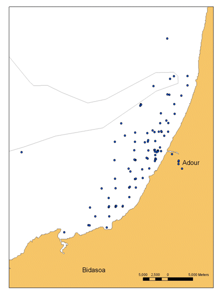
The BATEL-1 cruise was conducted from 4 to 14 June 2007 by the University of Bordeaux-1 (EPOC laboratory). The main objective was to obtain a database of optical and geochemical data in order to create algorithms to quantify the suspended particles and dissolved substances for the interpretation of MODIS, SPOT, ASTER and FORMOSAT-2 satellite images. The end purpose is to identify coastal water composition from satellite images. The second aim was to monitor the Adour river's turbidity plume during this period. In addition, measurements were taken to analyze the heavy metals, stratification of water masses (CTD) and for intercomparison of two fluorimeters. These measurements are currently being used by Ms. Petus (Thesis, Cifre grant). The cruise fell under the interregional Aquitaine-Euskadi programme.
-
Participation in validating the CAROLS airborne L band radiometer, during flights on ATR42. CTD/LADCP stations performed on repeated sections around the Bay of Biscay and calibration of CTD tags intended for deployment on sea elephants. The related projects are CAROLS, SMOS (TOSCA/CNES and ESA), EPIGRAM (LEFE/IDAHO).
-
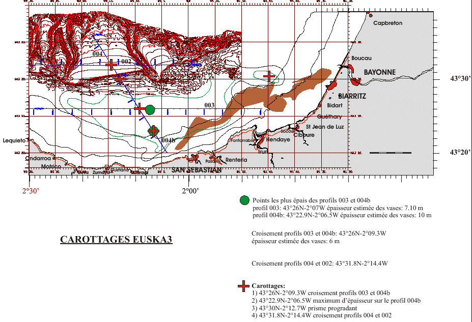
Core sampling on the mudflat of the Basque continental shelf. This falls under the Aquitaine / Euskadi project.